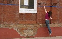
Thunderstorms in southern England brought torrential rain, large hail and flash flooding on 18 July, 2017.
Emergency services responded to flash flooding in Kent, Berkshire and Cornwall, where helicopters were used to carry out flood rescues.
Cornwall
Major flash flooding hit the coastal village of Coverack in Cornwall, on 18 July, 2017.
Torrents of water over 1 metre deep swept through the village after a period of heavy rain. Flood water and debris made roads in and out of the village impassable.
Two people trapped in their home had to be rescued by a coastguard helicopter.
Local authorities said that around 50 properties were affected and families were forced to evacuate. An emergency centre was opened in Truro’s County Hall by Cornwall County Council to respond to the flood situation.
Cornwall County Council said: “Cornwall’s emergency centre leading response to flash floods in Coverack. Members of Cornwall Council’s Localism team are supporting local residents affected by flooding in Coverack.”
According to the latest reports, all those trapped on their homes had been rescued and no casualties were reported.
Rainfall
The heavy rain was extremely localised, with none of the main weather stations in the area recording significant rainfall levels.
John Curtin, Executive Director of Flood & Coastal Risk Management, Environment Agency, said via Social Media that weather radar images show just how localised the Coverack storm was and that unverified totals look like 100mm of rain in three hours.
Weather radar image showing just how localised #Coverack storm was – unverified totals look like 100mm in three hours #CoverackStorm pic.twitter.com/IdSIz003fD
— John Curtin (@johncurtinEA) July 19, 2017
Social Media
This is the moment @MCA_media rescued a woman in her 70s, stranded by flash flooding in #Coverack #Cornwall pic.twitter.com/NnZBkqoo0Q
— ITV News WestCountry (@itvwestcountry) July 18, 2017
Exceptional #rescue by firecrews and #coastguard of elderly couple trapped in #Coverack flash floods pic.twitter.com/31uFVFfaQx
— Mullion Fire Station (@MullionCFRS) July 18, 2017
Major flooding in #Coverack area please avoid this area & do not attempt to drive through any flood water.
— Cornwall Fire&Rescue (@CornwallFRS) July 18, 2017
#Coverack #cornwall @CornwallFRS pic.twitter.com/29EeVzXGXb
— Leah (@LeahLily11) July 18, 2017
More scenes from #Coverack where an "instantaneous" torrent of water has hit the village. Latest here: https://t.co/8vVuTSs0tt pic.twitter.com/FkQj8ruWYG
— ITV News WestCountry (@itvwestcountry) July 18, 2017
.@CornwallCouncil say water in Coverack is receding after the flash floods. Video by @NancyCGates #HeartNews pic.twitter.com/lb4ootgaPZ
— Heart Cornwall News (@HeartCornNews) July 18, 2017
Kent
Flooding was also reported in Tunbridge Wells in Kent. Fire crews were called out to assist flood victims and pump out flooded homes. No casualties were reported.
Berkshire
In Berkshire, local media said that a school of around 1,8000 pupils was forced to close on 19 July after flood damage caused by the storm the previous day.
The school Tweeted that 51mm of rain had fallen in just 2 hours.
https://twitter.com/MESchoolweather/status/887409979480735744
The Reading University gauge recorded 40.2mm for the day, with 37.5mm of that falling in 1 hour.
40.2 mm (1.58 in) of rain fell yesterday evening (including 37.5 mm in 1 hour!) associated with MCS-type #thunderstorm via @UniRdg_Met obs. pic.twitter.com/e7i5dLrPp0
— ReadingUniWeather (@ReadingUniWx) July 19, 2017
The UK’s Met Office said that 42.4 mm of rain was recorded in 24 hours on 18 July in Reading.
Surface flood was reported in several parts of the large town of Reading. Local media said that “scores of homes, businesses and schools flooded and motorists getting stuck in deep water.”
.@getreading @rdgchronicle Northumberland Avenue last night! Wow! #RDGUK pic.twitter.com/hBGljZMSIX
— Memories of Mayo (@Gorman1871) July 19, 2017
Further Rainfall Warnings
The Met Office issued further warnings for heavy rain on 19 July.
“Thunderstorms, with locally torrential downpours will continue to move north across England and Wales in the early hours of this morning. Although the thunderstorms will tend to ease from the south later in the night, further, possibly severe storms may break out again this afternoon, probably focused over parts of northeast Wales, central and northern England. Although some places will miss the thunderstorms, there is a chance of localised sudden flooding of homes, businesses and roads. Frequent lightning and large hail may be additional hazards, the latter bringing potential for disruption to power networks. This warning has been updated to keep the risk going over southern England through the early hours of this morning.”