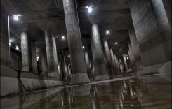
The Environment Agency in England says that over 550,000 homes were protected by flood defences as stretches of the East coast of England were hammered by high waves and storm surge between 13 and 14 January.
Waves of over 7 metres were recorded on 13 January in some areas. The combination of waves, strong winds, high tide and storm surge caused flooding up and down coastal areas of eastern England.

However, the Environment Agency said things were not as bad as predicted because the “combination of the peak surge, strongest winds and largest waves didn’t coincide in all areas, and did not reach the most dangerous levels that were possible all along the east coast”.
Damage was kept to a minimum by flood defences and pre-emptive evacuations ensured the safety of residents in affected areas. According to the BBC, more than 15,000 people in Great Yarmouth, Norfolk, were told to evacuate. A further 200 evacuations were carried out in Cromer, Norfolk. Over 1,800 people were evacuated in east Suffolk and over 300 in coastal areas of Essex, including Jaywick, Mistley and West Mersea.
The Hull tidal barrier was called into operation, protecting 17,000 homes ion the Hull area. Over 700 trained staff worked to protect communities, erecting 8,000 metres of temporary barriers.
In a statement on 14 January, Doug Wilson, Flood Duty Manager at the Environment Agency said:
“High tides and strong winds caused large waves along the East Coast yesterday, bringing a risk of significant flooding and danger to life.
“The Environment Agency issued over 100 flood warnings, operated its permanent flood defences including the Thames Barrier and Hull Barrier, and set up temporary defences in areas at risk. These actions protected over 550,000 properties.
“In the event, the combination of the peak surge, strongest winds and largest waves didn’t coincide in all areas and did not reach the most dangerous levels that were possible all along the East Coast.
“Some properties in North and East Yorkshire were flooded and our thoughts are with those affected.
“Environment Agency teams are out on the ground today inspecting and repairing any damaged defences, and will continue to warn and inform the public of flood risks, as necessary. We wish to thank the emergency services, local authorities, the military and volunteers who worked with Environment Agency staff to prepare for this event.”
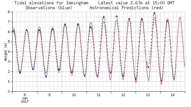
The images below from the National Oceanography Centre (NOC) show the tide and storm surge levels in parts of the east coast of England. Click on the images to see a larger version.




Social Media
VIDEO: 4:45pm #TidalSurge #Scarborough @itvcalendar pic.twitter.com/oqCTeDRakd
— Michael Newton (@Camera_Mikey) January 13, 2017
Earlier as Whitby began to flood. #stormsurge pic.twitter.com/9ozeerw4Be
— YorkshireCoastRadio (@YorksCoastRadio) January 13, 2017
#Hornsea – Picture of the sea coming over the sea wall from @hornsea_rescue's Glenn Ramsden. #stormsurge pic.twitter.com/TEN6sLRjF2
— BBC Radio Humberside (@RadioHumberside) January 13, 2017
Foreshore Rd in #Scarborough as storm surge begins to impact – high water due in 45 mins residents & business braced @BBCLookNorth pic.twitter.com/ZsTv1lI4Ib
— Phil Bodmer (@philbodmer) January 13, 2017
Hull Barrier closed to protect 17000 properties from east coast surge – learn more here https://t.co/Pl3QcKnpjo #floodaware pic.twitter.com/sGHo85AbQU
— John Curtin (@johncurtinEA) January 13, 2017
@JacksonHyder team out in force installing 145m of temporary flood barrier in Rochford, Essex for @EnvAgencyAnglia #floodaware #StormSurge pic.twitter.com/vKF6NUJXaz
— JacksonHyder (@JacksonHyder) January 13, 2017
Unbelievable scenes in #Scarborough this afternoon pic.twitter.com/aQANm1hoPE
— ITV News Calendar (@itvcalendar) January 13, 2017
Waves breaching defences at #Hornsea. Flooding likely to be less severe than last night pic.twitter.com/rcNTUzO66r
— Brid, Driff, Hornsea (@HP_BridDrifHorn) January 14, 2017