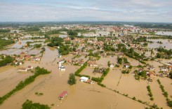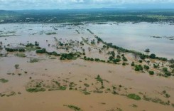
Some areas of Ca Mau Province in southern Vietnam are under 50cm (20 inches) of water after unusually high tides over the past few days.
The high tide season along this coastline usually runs from December to March. The floods over the last few days have caught a few buy surprise. The average water level is 30 cm higher than in previous years, officials say.
VNS are reporting that the entire coastline of the province – all 252 km (156 miles) of it – has been been flooded. Furthermore, areas inland have also seen some flooding, including Nam Can Town in Nam Can District. More than 2,000 hectares of aquaculture farms and 1,000 hectares of crops and orchards have been damaged by the tides. Saline intrusion has long been of major concern to local industries such as shrimp and rice farming.
VNS say that local officials see the recent high tides as part of the effects of rising sea levels and climate change. As a response, the province is aiming to build a sea dyke along its eastern coastline, and also repair and make improvements to the existing western sea dyke.
Map:
[mappress mapid=”271″]