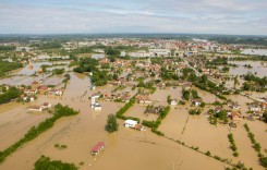
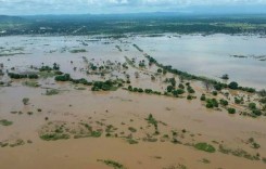
The St John River in New Brunswick Province, Canada, is at record levels and is expected to rise further. Flooding has damaged homes and roads and prompted evacuations.
Authorities have urged residents in the city of St John to leave their homes. On Social Media officials warned: “Evacuate today. Saint John EMO warns that water levels are rising. Residents in affected areas may lose power, water & sewer services soon. You may also be isolated & First Responders will have trouble reaching you in an emergency.”

As of 03 May, around 260 resident had evacuated. The government of New Brunswick added that “residents in the communities of Jemseg, Gagetown, Hampstead, Belleisle, Grand Bay-Westfield, Quispamsis…and Saint John, as well as smaller communities in these respective regions, should take all necessary precautions.”
Water levels in rivers began to increase throughout the province from 23 April as a result of continuous snow melt. Flooding has affected areas across New Brunswick over the last 5 days, causing damage to properties and closing 80 roads and bridges, including part of the Trans-Canada highway between Moncton and Fredericton.
The provincial government is receiving assistance from the Canadian Coast Guard to help with flood relief efforts.
“It is clear that due to flooding there will be houses and families isolated. We will be managing a long and complex event, and we will need to support New Brunswickers in many ways,” said Premier Brian Gallant. “We are therefore taking steps to increase our capability for marine operations. We have requested assistance from the Canadian Coast Guard. They have granted our request and will help us reach out to those impacted.”
The St John River was above flood stage in 7 locations in the province: Fredericton, Maugerville, Jemseg, Grand Lake, Sheffield-Lakeville Corner, Oak Point and Quispamsis-Saint John.
At Quispamsis-Saint John, the river reached a record 5.34 metres on 03 May, over 1 metre above flood stage of 4.2. The previous high was 5.31 metres set in 1973. The river is expected to rise further, possibly reaching 5.9 metres by Monday 07 May.
New Brunswick Premier, Brian Gallant, said “This is most likely going to end up being the largest, most impactful flood that we have ever recorded here in New Brunswick, so it certainly puts all of our resources and people to the test.”

Social Media
— Gouvernement du NB (@Gouv_NB) May 3, 2018
Please stay off flooded roadways. It is very dangerous. Reccomended Evacuations are in affect. #nbflood2018 #riverwatch2018 #saintjohnflood2018 pic.twitter.com/IAZgi8gEOq
— Saint John Police (@saintjohnpolice) May 3, 2018
Evacuate today. Saint John EMO warns that water levels are rising. Residents in affected areas may lose power, water & sewer services soon. You may also be isolated & First Responders will have trouble reaching you in an emergency. Call Red Cross 1-800-863-6582 #RiverWatchSJ pic.twitter.com/xRNZ4Fz0zo
— City of Saint John (@cityofsaintjohn) May 3, 2018
DFO fishery officers on station with @NBEMO_OMUNB and partners. Assisting residents as they evacuate #NBFlood2018 pic.twitter.com/Y790B0gHup
— DFO Maritimes (@DFO_MAR) May 3, 2018