“The massive costs and damages to Vancouver resulting from climate change and sea level rise can’t be ignored,” says Mayor Gregor Robertson. “Sitting on the sidelines is not an option while climate change threatens our future.”
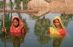
Scientists project that sea level rise will pose a significant challenge to coastal cities across the world over the next century and beyond. And the city of Vancouver, on the coast of British Columbia, Canada’s westernmost province, is no exception. Sea levels there are expected to rise 1 metre by 2100.
Vancouver, therefore, has been planning and preparing for the impacts of sea level rise across the city over the last few years.
Vancouver Mayor, Gregor Robertson, said:
“By taking action today to protect our land, environment, people’s homes, and our iconic landmarks from climate change impacts, we’re making our city more resilient and saving billions of dollars in the long run.”
The city is already actively adapting to climate change with initiatives including sewer separation, water conservation, green building standards, flood-proofing guidelines for new developments, and hot weather preparedness strategies.
Recent reports on coastal flood risk in Vancouver, commissioned by the city, have now identified possible options for responding to coastal flood risk in areas along Vancouver’s coastline.
Vancouver’s Climate Change Adaptation Strategy
As part of the city’s Climate Change Adaptation Strategy, Vancouver partnered with multiple stakeholders to commission a two-part Coastal Flood Risk Assessment to understand the impacts and potential solutions.
The first report, City of Vancouver Coastal Flood Risk Assessment Phase I (pdf), was completed in 2014 and identified flood hazards, vulnerabilities, and consequences expected over the next century, and led to a new floodplain map with new flood construction levels.
A second report, City of Vancouver Coastal Flood Risk Assessment Phase II (pdf) was completed in December last year and put to council last week. It identifies possible options for responding to coastal flood risk in eleven distinct areas of Vancouver’s coastline.
Compass Resource Management, Ebbwater Consulting, Northwest Hydraulic Consultants and Urban Systems were retained by the City to help them better understand the risks, to develop high-level adaptation options and to create a unique, inclusive decision-making process to explore trade-offs between various adaptation options.
Ebbwater Consulting, a Vancouver-based firm that works at the nexus of engineering, planning and policy with a focus on flood and climate adaptation, led the technical team, developed new methods for risk assessment that fed the options assessment, and co-authored reporting.
About the project, Ebbwater Consulting said: “This project breaks new ground in evaluating the implications and timelines of sea level rise on coastal communities, and provides a model for other communities grappling with the challenges of assessing and managing flood risks from a rising sea. The project included several leading-edge concepts for climate adaptation in Canada.”
Increasing Flood Risk
Sea levels are expected to rise 1 meter within the next 100 years in and around Vancouver and along the coats of British Columbia, according to research by the Province of British Columbia.

While the flood risk today and in the short term is limited to a few areas of Vancouver, the flood risk increases through time when sea level rise is added to the equation, particularly during an extreme weather event.


In 2017, the city plans to begin engaging with neighbourhoods that will be the most impacted by sea level rise in the near future to identify the best adaptation options, including:
- Protect land from flooding via green infrastructure, flood walls, tide gates, dikes
- Adapt to new flood realities by raising buildings and infrastructure, changing construction practices, and implementing temporary barriers
- Retreat by removing people and infrastructure over time from areas exposed to flood risk
Phase II also looked at the potential timing of flood risk in order to recommend when interventions should occur and proposes an adaptive management framework to monitor and re-assess over time.
These findings will provide the basis for a future sea level response plan to address sea level rise over the next century, with medium- and long-term actions that complement the the city’s existing climate change mitigation strategies.
Resilient Infrastructure
The report’s findings will also be incorporated into the planning of future coastline projects. This will ensure that Vancouver builds and plans resilient infrastructure, and neighbourhoods, and so preserve the ability to implement flood management interventions when needed in the future.