Hurricane Maria has continued its trail of destruction in the Caribbean, making landfall near Yabucoa, Puerto Rico on 20 September with maximum sustained winds of 155 mph (250 km/h).

Dominica, Guadeloupe and Virgin Islands
Maria had already caused massive destruction in Dominica and the French island of Guadeloupe, and storm surge and flooding in the Virgin Islands.
Caribbean Disaster Emergency Management Agency (CDEMA) reported that Maria had impacted all of Dominica, with significant damage to housing, Canefield airport and Roseau hospital. The capital city Roseau is flooded. CDEMA say that around 60,000 people have been affected by the storm. At least 7 deaths have been reported in Dominica.
One death was also reported in Guadeloupe. According to WMO reports, 246.4 mm of rain fell in a 24 hour period to 20 September in Le Raizet, Guadeloupe.
Heavy rain and storm surge rather than wind caused much of the damage on the island of Tortola, British Virgin Islands. Roads have been damaged or covered in debris. Some minor landslides were also reported.
Puerto Rico
Maria made landfall near the city of Yabucoa on Wednesday 20 September, bringing with it with strong winds, torrential rain and storm surge.
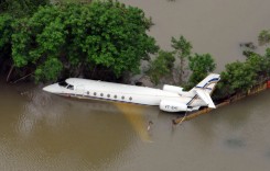
Preliminary reports suggest that the damage in Puerto Rico is widespread and severe. Strong winds tore off roofs and downed power and communication lines. Electricity was cut throughout the entire island.
Storm surges flooded many coastal areas. A National Ocean Service tide gauge at Yabucoa Harbor recently reported a water level of 5.3 ft (1.61 metres) above Mean Higher High Water.
Extreme rainfall rates—some areas reported 5 to 7 inches (130 to 180 mm) falling per hour—fuelled destructive flash floods and landslides.
Per @NWSSanJuan…these are the rain rates occurring now in P.R. No wonder the life-threatening rainfall #flooding ongoing. #Maria pic.twitter.com/KDLkFOcy5L
— Jonathan Erdman (@wxjerdman) September 20, 2017
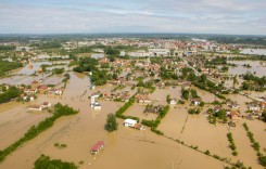
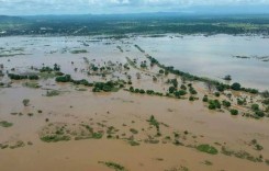
River levels increased dramatically with the torrential rain, in particular the Rio Grande de Manati and Rio de la Plata. By early 21 September, rivers at at least 10 locations had have exceeded Major Flood Stage.
Update: 22 September.
NWS Miami issued some preliminary rainfall figures for a 24 hour period to 15;30 hrs, 21 September, 2017
- L Garcia, Caguas – 37.9 inches / 962.66 mm
- Villalba – 27.82 inches / 706.63 mm
- Lomas, Canivanas – 23.89 inches / 606.80 mm
- Sumidero, Caguas – 23.43 inches / 595.12 mm
23 locations recorded more than 10 inches (254 mm) of rain in 48 hours, and 6 locations more than 20 inches (508 mm).
Preliminary Hurricane Maria Information from PR & USVI #prwx #usviwx pic.twitter.com/PcQtTLPuax
— NWS San Juan (@NWSSanJuan) September 21, 2017
Flood Warnings
Via Social Media, NWS San Juan said “Puerto Rico is now completely under a Flash Flood Warning. If possible, move to higher ground NOW!”
As of early 21 September, Maria located northwest of Puerto Rico, but “still causing catastrophic flooding throughout the island” according to NWS.
Puerto Rico is now completely under a Flash Flood Warning. If possible, move to higher ground NOW! #prwx pic.twitter.com/TOrVnXaKOR
— NWS San Juan (@NWSSanJuan) September 21, 2017
Late yesterday Puerto Rico Governor Ricardo Rossello said. “The danger continues – there is notice of floods for all Puerto Rico. Remain in safe locations.”
Hurricane Maria Track
In their latest Advisory, the National Hurricane Center said:
“On the forecast track, the core of Hurricane Maria will continue to move away from Puerto Rico during the next several hours, and then pass offshore of the northeastern coast of the Dominican Republic early today. Maria should then move near the Turks and Caicos Islands and the southeastern Bahamas tonight and Friday.
“Maximum sustained winds have increased to near 115 mph (185 km/h) with higher gusts. Maria is a category 3 hurricane on the Saffir-Simpson Hurricane Wind Scale. Some additional strengthening is possible over the next day or so.”
NHC warned that storm surge of up to 6 feet (1.83 metres) and rainfall of 35 inches (890 mm) is possible in some areas.
Social Media
WATCH: Floodwaters rush through streets of Guyama, Puerto Rico as Hurricane Maria strikes the island (via Cruz Rodriguez Keila) pic.twitter.com/apJvSRibDV
— NBC News (@NBCNews) September 20, 2017
https://twitter.com/9ablo/status/910492181521207296
The river gauges across Puerto Rico are all going straight up toward record flooding with a lot of rain yet to come. #Maria pic.twitter.com/4viPohPJBJ
— Eric Fisher (@ericfisher) September 20, 2017
https://twitter.com/eamolero/status/910484713369853953
#Caguas #HuracanMaria #HurricaneMaria #Maria #PuertoRico pic.twitter.com/jIBMp3ixGX
— Valeria M. Aponte (@ValeriaMarieAH) September 20, 2017
So esta es la que hay en Ciudad Jardin de carolina pic.twitter.com/cMNY1DDT6H
— french toast (@frances_mh) September 20, 2017
@adamonzon Los Colobos Carolina pic.twitter.com/QM9oz5rlwg
— frances guzman (@franeguz) September 20, 2017