After causing devastating damage across the Caribbean, Hurricane Irma made landfall in the Florida Keys on 10 September and worked it’s way north, bringing with it strong winds, storm surge and flooding rain.
Irma has since weakened to a Tropical Depression but heavy rainfall remains a threat for many south eastern states.
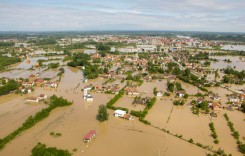
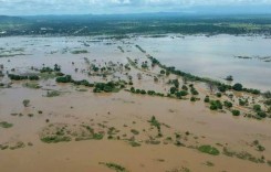
While the Florida Keys and south western areas of the state suffered some of the worst of the winds – gusts of 131 mph (210 km/h) were recorded at Naples Municipal Airport – it was Florida’s north east that appears to have taken the brunt of the flooding.
Irma has dumped as much as 400 mm of rain in some areas of Florida in the last 3 days. Storm surge and heavy rain conspired to cause rivers to reach record highs in Jacksonville yesterday, 11 September. Flooding also affected coastal areas of Georgia and South Carolina, including Charleston.
The city of Jacksonville said via Social Media that the St. Johns River experienced its worst flooding levels since 1846.
This is an incident of historic proportions. The St. Johns River has not seen these flooding levels since 1846. #HurricaneIrma #JaxReady pic.twitter.com/8awsM7lvGy
— City of Jacksonville (@CityofJax) September 11, 2017
Rivers
As of 12 September, NWS Southeast River Forecast Center said that 28 river gauges were at or above major flood stage, including the Nassau, Broward, Cedar, Ortega and St Johns rivers in and around the Jacksonville area.
Cooper River at Charleston, South Carolina, reached 9.92 feet on 11 September, exceeding major flood stage of 8 feet.
In Jacksonville, the Borward River reached 8.01 feet and the Cedar River 6.35. The St Johns River reached record highs of 5.57 feet at Main Street Bridge and 5.63 feet at Buckman Bridge on 11 September, 2017.


Storm Surge
Although severe, overall the storm surges in south western areas of the state were lower than feared.
Fort Myers and Naples saw sea levels surge between 1 to 2 metres above normal levels. As of early 12 September, water levels along the Gulf Coast of Florida from Fort Myers to Cedar Key are measuring 1.2 to 2.4 feet (0.36 m to 0.73 m) above tidal predictions, according to NOAA / National Ocean Service.
Irma’s track inland through Florida helped lessen the storm surge, the New York Times explains:
“At the last minute, Irma unexpectedly veered inland right before it got to Naples, taking its eastern wall safely away from the ocean. That meant that as the storm tracked north over Naples, Fort Myers and Tampa Bay, the winds at the head of the storm were moving west and actually pulling water away from the shoreline…”
“Then, once the eye of the hurricane had passed through those areas, the back side of the storm hit, pulling water east toward the coast. But by this point, the storm’s winds were weakening, and the resulting surge was not nearly as strong as feared.”
This initial drop before the rise can be seen in charts from some of the National Ocean Service sea level stations in western Florida.


Rapid rises occurring now at Steinhatchee River. Those beach areas where water receded far away? Yep- it's coming back and quick! pic.twitter.com/LLPmWcaWM5
— NWS Tallahassee (@NWSTallahassee) September 11, 2017
Rainfall
Irma dumped between 10 to 16 inches of rain (250 to 400 mm) of rain in many areas in the last 3 days.
Below are NWS preliminary storm total rainfall in inches for a period from 08:00 EDT on 09 September to 22:00 on 11 September, 2017.
Florida
- Fort Pierce St. Lucie County Airport – 15.91
- Oviedo – 14.76
- Chekika – 13.83
- Naples – 11.87
- West Melbourne – 11.2
- Jacksonville – 11.17
- Fort Myers Intl Airport – 10.33
Georgia
- St Marys River near Kingsland – 10.12
- Cumberland Sound near St Marys – 9.18
South Carolina
- Edisto Island – 6.05
Some of the heaviest rain in Georgia and South Carolina fell in the last 24 hours to 12 September.

Flooding Rain Forecast for 7 States
Although no longer a hurricane, Irma continues to produce very heavy rain across the south eastern United States. In its final storm summary for Irma, NHC said:
“Significant river flooding will persist over the Florida peninsula in the wake of Irma and across Georgia, South Carolina and north-central Alabama where additional heavy rains are expected.
“Portions of these states within the southern Appalachians will be especially vulnerable to flash flooding. Irma is also expected to produce heavy rains in northern Mississippi and southern portions of Tennessee and North Carolina, where local flooding may occur.”
Irma’s Track Through Florida
After sweeping through the Caribbean as a Category 5 hurricane, Irma landed on the Florida Keys early on 10 September as a Category 4 hurricane.
After sweeping through the Keys and on to Florida’s southwestern coast, Irma made its second USA landfall in Marco Island as a Category 3 during the afternoon 10 September. It later reached the Tampa Bay area as a Category 2 storm.
Late on Monday, 11 September, the National Hurricane Center (NHC) said that Irma had weakened to a Tropical Depression.

Damage and Response
At least nine deaths in the U.S. have been attributed to Irma. Many of the fatalities were caused by the wind damage.
At one point 6.5 million homes and businesses were without power in Florida. News images showed flooded streets and coastal areas, wind damaged buildings, uprooted trees, boats cast ashore, downed power lines and upturned mobile homes.
However, the full extent of the damage is not yet known. Florida officials say that once conditions have improved, individual counties will start their initial damage assessment process.
Florida Governor, Rick Scott, has activated the entire Florida Army and Air National Guard – 7,935 guard members – to support planning and logistical operations in preparation for impacts from Tropical Storm Irma. The Florida National Guard has 1,000 high water vehicles, 13 helicopters, 17 boats and more than 700 generators to support these efforts.

Evacuations
The Department of Emergency Management in Florida estimates that 6.5 million people have been ordered to evacuate.
More than 585 shelters are open throughout Florida with a total population of more than 200,000 individuals.
Social Media
Take a look at the rainfall totals from #Irma! This is one reason several rivers are going into major #flood stage. #flwx pic.twitter.com/evh9igikui
— NWS Tampa Bay (@NWSTampaBay) September 12, 2017
This is Jacksonville… No words. pic.twitter.com/34FT7B0Snk
— Meilin Tompkins (@MeilinTompkins) September 11, 2017
For those contemplating driving around (down)town today…this seems to be a recurring theme. #JSO recommends not. pic.twitter.com/NSpvt1XV0q
— Jax Sheriff's Office (@JSOPIO) September 11, 2017
This is an incident of historic proportions. The St. Johns River has not seen these flooding levels since 1846. #HurricaneIrma #JaxReady pic.twitter.com/8awsM7lvGy
— City of Jacksonville (@CityofJax) September 11, 2017
https://twitter.com/KevRincon/status/907226975902855168
#GOES16 captured this imagery of #Irma from landfall yesterday up until mid-morning 9/11. Get the latest info @ https://t.co/cSGOfrM0lG pic.twitter.com/DgLLqijRiM
— NOAA Satellites (@NOAASatellites) September 11, 2017
History of Hurricane #Irma: 1 September 2017 – 10 September 2017 #GOES16 pic.twitter.com/Z53paEmpIY
— NASA SPoRT (@NASA_SPoRT) September 11, 2017