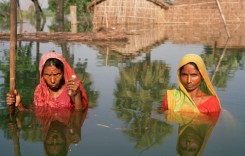
Snowmelt has triggered flooding in parts of northern Montana, prompting Governor Steve Bullock to declare a state of emergency. The Marias River has reached record heights and the Milk River its highest level in 60 years.
The state of emergency has been issued for the Fort Belknap Indian Reservation, the Town of Chester, and Pondera, Hill, Blaine, Valley, Toole, Liberty, and Petroleum Counties. The declaration will allow the use of state government services and equipment, and let the U.S. Army Corp of Engineers help protect infrastructure.
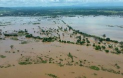
Rapid snowmelt and flooding have impacted the Milk River Basin and Marias River Basin. United States Geological Survey (USGS) in Montana said that along the Milk River basin, near-record flood crests are expected later this week or early next week. The overflowing rivers and tributaries have flooded roads and wide areas of farmland.
National Weather Service Great Falls issued a flood warning on 18 April for areas around the town of Harlem after levels of the Milk River increased and a local creek overflowed. Authorities ordered several homes to evacuate.
USGS Montana said that as of 19 April, the Milk River had reached stage (13.93 feet) and flow not seen since 1952.
On 19 April a flood warning was issued for areas around the town of Harvre as a result of the Big Sandy Creek overflowing, and for Chinook after levels of Battle Creek increased.
River levels are expected to remain high for some time, possibly until May. The governor’s statement said that near-record snowpack in nearly every river basin across Montana is expected to melt off as temperatures begin to rise.
“As Montanans are faced with flooding, we are doing everything necessary at the state level to protect health and safety, and to preserve lives, property, and resources,” said Governor Bullock.
“We continue to keep in close communication with local and tribal officials as we monitor conditions around the state.”


Social Media
Preliminary data show a new peak of record flow on the Marias River near Loma last night (29 years of data). Streamflow measurement yesterday (red star) is the highest ever measured at that site. https://t.co/aio6iFnoX3 #MTwx pic.twitter.com/CC7bgU985A
— USGS in Montana (@USGS_MT) April 19, 2018
@NWSGreatFalls flooding in Harlem from 30 Mile Creek. At least one disabled citizen has been displaced #mtwx pic.twitter.com/0sbT6Pt6Qn
— Arin Peters (@arinpeters) April 18, 2018
Perspective: the top photo is what Milk River near Havre looked like on a fall day, flowing 50cfs. Today (bottom photo), the flow is over 7200cfs. (Avg for today is 400cfs.) Red line in both photos appx same location. Real-time data: https://t.co/XYYV1gkA4m pic.twitter.com/ZPoGG639HA
— USGS in Montana (@USGS_MT) April 18, 2018
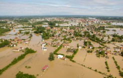
Featured photo: File photo – Milk River floods near the towns of Glasgow and Tampico, Montana in 2011. Photo: U.S. Army Corps of Engineers, CC BY 2.0
Flood Summary
Locations
B - Chinook
C - Harlem
D - Loma
Magnitude
Milk River, Harlem - April 19 to April 19, 2018
23.75 feet
Battle Crek Chinook - April 18 to April 18, 2018
12.80 feet
Big Sandy Creek Harvre - April 18 to April 18, 2018
14.03 feet
Damages
Montana - April 18 to April 20, 2018
Montana Dept of transport said roads across northern parts of the state were flooded in 13 locations
Harlem, Montana
Estimated figure. Evacuation notices were given by authorities in Harlem. However, as of 20 April is was not clear how many people have evacuated their homes.