Record rainfall from Tropical Storm Beta caused flooding in parts of Texas, USA, from 22 September.
Beta made landfall over Matagorda Bay along the coast of central Texas on 22 September, 2020 with maximum sustained winds of 75 km/h.
Beta dumped more than 16 inches / 400 mm of rain as it made its way over Texas. National Weather Service (NWS) in Houston said Beta brought new daily rainfall records for the City of Houston with 3.58″ / 90.93 mm, breaking the previous record of 3.15″ / 80 mm from 1965. New daily records were also set at Houston-Hobby, with 7.32″ / 185.93 mm of rain falling on 22 September, shattering the old record of 3.86″ / 98 mm set in 1997. NWS Houston added that this was also largest single day total at Houston-Hobby since Hurricane Harvey. In 2017.

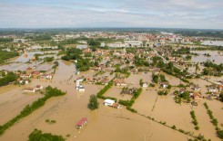
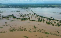
Extensive flooding was reported across Houston and surrounding areas after heavy rainfall swamped roads and caused rivers and bayous to overflow, including the Buffalo Bayou which flooding streets in Downtown Houston.
The Texas Department of Transportation said that 37 different locations were impacted by high water as of late 22 September. Several vehicles were left stranded on flooded freeways. Houston Mayor Sylvester Turner urged residents to stay at home and off the roads.
Houston Fire Department said they responded to just over 100 request for high water evacuations and swift water rescues in the past few days. Houston Police Department said a fisherman was reported missing in Brays Bayou.
Water levels around Houston were beginning to recede in some locations by 23 September. However, Beta is expected to move over Louisiana, Arkansas, and Mississippi, bringing the risk of flash flooding.
Social Media
HFD responded to just over 100 Request for high water evacuations and swift water rescues these past few days. HFD Rescue Teams are continuing to monitor our Houston area rivers and bayous. @FireChiefofHFD pic.twitter.com/NcHek6entF
— Houston Fire Dept (@HoustonFire) September 23, 2020
Buffalo Bayou overflowing and flooding streets in Downtown Houston. @hcfcd pic.twitter.com/pDaD3rbcIr
— Ian Shelton (@IanShelton1997) September 22, 2020
HPD & our @USCG partners are searching for a fisherman who jumped into the water just after 6 p.m. He reportedly entered Brays Bayou near East Navigation and Harrisburg. #hounews
— Houston Police (@houstonpolice) September 23, 2020
HIGH WATER ALERT: Entrance High Meadows subdivision Russ St At Aldine Mail Route. pic.twitter.com/lxUCHtDHol
— Harris County Commissioner Pct 2 (@HarrisCoPct2) September 23, 2020
Alert Houston: Areal Flood Warning for much of Houston until 2:00 a.m. Street flooding is likely in low-lying an flood prone areas. Do not travel through high water. https://t.co/lUpjmQ4421
— AlertHouston (@AlertHouston) September 23, 2020
7:45 AM, 9/22/20 UPDATE: LA 1 is still closed at this time south of the Leon Theriot Lock in Golden Meadow. We will keep you posted on any changes today. #Beta #lawx pic.twitter.com/odSSXS8voa
— Lafourche Parish Sheriff’s Office (@LafourcheSO) September 22, 2020
#Beta brought new daily rainfall records yesterday to:
– City of Houston with 3.58″ breaking their old record of 3.15″ (1965).
– Houston-Hobby with 7.32″ shattering their old record of 3.86″ (1997) – this was also largest single day total at the site since Harvey.#TXwx #HOUwx pic.twitter.com/AKeEorRc3R— NWS Houston (@NWSHouston) September 23, 2020
Beta certainly left a mark! Below is a 3-day accumulated precipitation estimate since early Sunday. The footprint of >5 inches of rain is most notable just inland of the TX coast. The highest observed rainfall (14.40 inches) was in Harris County, TX, close to the max estimate. pic.twitter.com/5c0sjM7ZMI
— NWS Weather Prediction Center (@NWSWPC) September 23, 2020