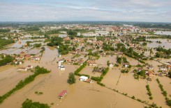
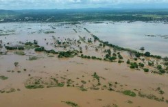
Tropical Cyclone “Son-Tinh” – known locally as “Henry” – brought heavy rain to parts of the Philippines between 15 and 17 July, with flooding reported in National Capital Region (Metro Manila), Bataan, Pampanga, Zambales and Occidental Mindoro.
The country’s National Disaster Risk Reduction and Management Council (NDRRMC) said that 7,880 people were being served inside and outside 12 evacuation centres that have been set up in affected areas. No casualties have been reported. Schools have been closed in parts of Metro Manila.
NASA’s Global Precipitation Measurement mission analysed the cyclone’s rainfall and showed that convective storms within the tropical cyclone were producing extremely heavy precipitation in the Philippine Sea near the northeastern tip of Luzon. GPM’s radar (DPR Ku Band) scans of these powerful storm showed that rain there was coming down at a rate of greater than 165 mm (6.5 inches) per hour.

Further heavy rain is expected in the Philippines as a tropical depression (known locally as Inday) heads towards northern parts of the country.
China and Vietnam
Tropical Cyclone Son-Tinh made a second landfall over Hainan Island in China on 17 July with maximum sustained winds of 65 km/h.
According to European Civil Protection and Humanitarian Aid Operations (ECHO), “Over the next 24 hours, it is expected to keep moving toward the west-northwest reaching the coast of the North Central Coast region in the afternoon UTC of 18 July. Heavy rain, strong winds and storm surge may continue to affect several areas of Hainan, Guangdong, Guangxi (China) and the northern Vietnam regions of northeastern, northwestern and Tin Bao Khan Cap over 18-19 July. Heavy rain might also affect northern LAO PDR and northeastern Thailand over 19-20 July.”