Indonesia’s capital Jakarta, situated on the north coast of the island of Java, lies within the metropolitan area comprising of DKI Jakarta (the capital area), parts of Bogor District (West Java Province), parts of Tangerang District (Banten Province) and Depok and Bekasi District (West Java Province). This metropolitan area on the coast of the Java Sea has a population of about 16 million and is expected to grow to about 30 million by 2030. The percentage of population below the poverty line is about 20%.
Jakarta has developed on low-lying land around the Jakarta Bay, where some 13 streams and rivers empty into the Java Sea. The older parts of the city are characterised by canals built by colonists in the 19th century for trading purposes, with more canals built in the 20th century to divert floodwaters. A Western Diversion Canal (West Banjir Canal) was constructed in 1919 and the Cengkareng Floodway in 1982. Construction on an Eastern Diversion Canal (East Banjir Canal) commenced in 2003, reportedly 30 years after being planned. Critics have noted that it will only reduce flooding in East Jakarta by 30%.

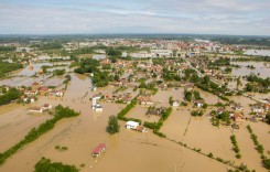
Jakarta is listed as second most vulnerable city in the recent WWF study on Asian coastal mega-cities. Flooding in the capital is a regular phenomenon, despite attempts to combat it, and has increased in severity. In January 2013, owing to the collapse of a canal dike, floods affected central business district around Thamrin Street, causing huge financial losses in a matter of hours.
Regular flooding in metropolitan Jakarta is caused by a combination of at least six factors that need to be addressed holistically in order to be effective in the long run.
Land Subsidence
The northern portion of the city, about 150,000ha of which is 2m or more below sea level, is steadily sinking, largely due to uncontrolled pumping of groundwater over the past few decades as informal settlement on the outskirts of the city has expanded. This will leave the northern parts of Jakarta some 4 to 5 metres below sea level by 2030, and, if subsidence is not stopped, north Jakarta will sink at least another 5-6 meters by 2100, compounded by a small rise in sea level. Even with the phasing out of groundwater pumping in the 2020s, further ground settlement in the north part of city by the end of the century would be in the order of 2 meters.
In order to phase out groundwater pumping and slow down land subsidence, it will be necessary to provide an adequate, affordable and reliable piped surface supply system.
Reduced water retention capacity
Population pressure has led to half the city’s small lakes (waduk) and public open spaces being converted into residential or commercial areas, resulting in a severe reduction in retention capacity and increasing peak flow discharge. Less than 10% of DKI Jakarta area can be defined as open and green space, whereas these should constitute 30% of land use, according to government regulations.
This reduction in water retention capacity leads to impeded drainage even for normal rainfall and will result in permanent inundations of some areas from the sea even at low tides, with these converted areas will become unsuitable for human settlement.
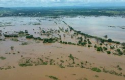
Increased runoff
Direct runoff within the city is much higher than the drainage system was originally designed to handle. With the growth of urban settlement, both formal and informal, the water retention capacity for direct rainfall has decreased, while runoff into the 13 rivers and streams that flow into Jakarta has increased owing to development in the catchment areas of Bogor and Puncak. Much of this runoff is badly polluted by human activities by the time it reaches the coast.
Sedimentation and obstruction of water channels
Sediment loads due to erosion and landslides caused by deforestation in the upper watershed are deposited in rivers, streams and canals, reducing their capacity to handle runoff. In addition, pollution and garbage have clogged waterways, reducing their ability to convey runoff efficiently.
Although a system of key flood gates exists in some of the urban area canals and retention ponds, these suffer from constant blockage owing to the above factors, and may not be properly operated in a regional manner as they were designed for a smaller colonial Jakarta.
Coastal Ecosystem Damage
Alan F. Koropitan, a lecturer of marine and fisheries studies at the Bogor Institute of Agriculture (IPB), said that massive quantities of nutrients and organic materials flushed out by rivers had badly polluted the Java Sea, damaging mangrove and coral reef ecosystems that protect land from waves and floods. Mangrove forests also play an important role as sediment traps and their loss weakens the ability of coastal areas to resist the impact of climate change, he said. Floods that coincide with high tide are further exacerbated by backup of the flow of rivers and drains.
Budgetary Constraints and Poor Management
The National Ministry of Public Works and Jakarta DKI are responsible for maintaining flood control infrastructure, but budgetary allocations are substantially less that that required to maintain the system. This has resulted in sediment and solid waste build-up in waterways and drains, reducing protection levels from 25 years to less than 5 years.
Jakarta Urgent Flood Management Programe (JUFMP)
Without doing something to protect the north of the city, including the functioning of the land support for Tanjung Priok, the country’s main seaport, then very large areas of land will be at risk as well as trillions of dollars of commercial assets.
DKI Jakarta has, with assistance from donors and central government, implemented numerous programmes in recent years to address flooding in the metropolitan area, including building additional floodways, cleaning out canals, and building a sea wall.
Jakarta Urgent Flood Management Programe (JUFMP) is a five-year World Bank-funded project aimed at priority areas in Jakarta’s flood management systems. It is planned that the backlog of maintenance dredging will be addressed, by removing 2 metres of sediment build-up and rehabilitating inoperable pumps. About 67.5 km of 11 key channel sections and 65 hectares of four retention basins will be dredged, to help restore their operating capacities. About 42 km of embankments will also be repaired in these sections. Most of the rehabilitation activities under the project are expected to be completed in the three years between 2012 and 2015.
Changes in runoff patterns and river flow characteristics, together with land subsidence in North Jakarta, have created a major challenge for the drainage system of DKI Jakarta. Because of land subsidence the natural outflow into the sea does not exist anymore at many sea-outfalls. It has been observed by the governor of DKI Jakarta that, while these measures will go a long way toward mitigating the impact of run-off waters under normal heavy monsoons conditions, they will not prevent flooding under extreme conditions.
The Jakarta Coastal Development Strategy (JCDS)
The Jakarta Coastal Development Strategy (JCDS) was formulated in 2011, after the Indonesian and Dutch government signed a Memorandum of Understanding in 2007, part of which involves both countries are closely working together to develop a strategy to resolve the flooding issue. The JCDS study was based on a so-called Triple-A concept, with the results documented in three reports, i.e. an Atlas (gathering all relevant data about the flooding situation and its causes), Agenda (identifying the interventions that need to be implemented) and Aturan-main (= Rules-of-the-game, the process of implementation of the interventions). Three alternative Scenarios for the coastal defence system of Jakarta were compiled, and these scenarios were subsequently merged into one development strategy that contained basic elements of the three individual scenarios aimed short, medium- and long-term flooding solutions.
The JCDS built on work previously undertaken and expanded it into a bold and innovative set of scenarios, based on the need to initially protect the city from large-scale inundation by ‘Extreme Proxigean Spring Tides’, spring high tides which fluctuate in 18-year cycles, with the next cycle expected to peak in 2025. Hence Phase 1 would involve raising the level of the existing seawalls and canal dikes to protect against flooding should the peak spring high tides coincide with heavy rainfalls in the river catchments, to be completed by 2020.
There was concern that, if subsidence is not halted, the seawalls developed in phase 1 of the JCDS will eventually be undermined and fail. In this case, Phase 2 envisaged a further dike being built 3km off-shore by 2030, to prevent the existing seawall from being undermined, with the area between the dikes used for water retention and future land reclamation, as well as extension of the existing harbour. The retention ponds were considered as a potential source of fresh water for the city, but, given the sanitation situation and the water quality of rivers flowing into the bay, the study considered it “most unlikely” that the water quality in the enclosed bay would meet the standard of bulk clean water supply within the next 50 years.
Phase 3 would consist of the construction of a further sea wall by 2040, about 8km seaward of the present coastline with pumps designed to remove 500 cubic meters of water per second, to counter rising sea levels as well as land subsidence. This phase would be accompanied by the construction of a new port and airport, as well as the development of residential and business areas on the dikes.
JCDS Plan 2012-2030
Recent reports indicate that the authorities have decided to omit the second phase of construction, since these features would only be effective for 10 years, and the city could make better use of its resources by moving ahead to Phase 3 of construction. This has brought the projected completion date forward significantly.
In total, a new 1,500ha city, and rapid transit lines, will be constructed along and within the wall, which will surround 10,000 ha in total, be 60 km long and extend 8 km out from the shore. The problems of creating retention ponds on prime land, creating cross-city transport routes, and expansion of the city’s commercial centre are all addressed with this concept, whilst other aspects such as providing piped water and other services to existing residential areas will need to be addressed simultaneously.
Once the master plan is completed, which is expected to take two to three years to prepare, Detailed Engineering Designs (DED) will be prepared. DED is proposed to be completed by 2015, after which the physical development will last for 10 years, hence by 2025 the giant dike will have been realised. DKI Jakarta Provincial Government will soon seek funding for the construction through the mechanism of public private partnership (PPP), because the funds needed to build this mega project amount to over Rp50 trillion (US$5.13 billion).
Sea walls, reclaimed land and retention ponds shaped like a Great Garuda, the national bird of Indonesia


To accommodate the present structure of the coastline, the most suitable shape of these dikes would appear to be a convex line, which has been depicted as a large bird in the initial sketches: the ‘Great Garuda’, Indonesia’s national symbol. To finance these plans, the Master Plan also includes massive land reclamation, much of which will be sold off for private development.
According to WaterfrontsNL, a group of Dutch companies with expertise in waterfront design, engineering, construction, operations, maintenance, and supplies,” These ambitious plans will protect Jakarta from flooding, in combination with revitalizing the city and adding land to develop a new city centre comprising of homes and offices. The plans provide for a crucial road that will restore mobility to the city and provide opportunities for ongoing development of North Jakarta. Top priority is to stop the groundwater withdrawal by building a water supply, reinforcing the present coastal defence and improving the quality of surface water”.
Head of DKI Jakarta Public Works Department, Ery Basworo, said that the existence of the giant dike will have major implications for the development of Jakarta. “The giant dike will also be made a toll road. The benefit is huge. This is a great plan that must be realised to save Jakarta from the threat of flooding and the brunt of the sea,” he said.
Deputy Head of DKI Jakarta Public Works Department, Tarjuki, said that although the construction costs “are very large indeed, the benefits will be felt by Jakarta residents for hundreds of years into the future”.
There are, however, those who are cynical about the proposed developments, pointing to corruption, slow decision-making and lack of co-ordination as obstacles in the way of such a large undertaking.
A Gallup poll in Indonesia released in October 2010 found that 91 percent of Indonesians believe corruption in government is widespread, while it had taken 30 years for the Eastern Floodway to get from the drawing board into the ground. In 2012 it was reported that although the former governor of DKI Jakarta, Fauzi Bowo, had included reference to the possible expansion of the Soekarno-Hatta airport onto the reclaimed land, the Transportation Minister EE Mangindaan claimed never to have heard of the proposal.
Despite the critics, Jakarta Governor Joko Widodo, better known as Jokowi, was reported as saying at the Jakarta City Hall on 20 November 2013 that he wants to accelerate construction of the Giant Sea Wall mega-project in North Jakarta. “If possible, we should make all the necessary preparations in 2014 and then begin the physical construction the year after that,” Jokowi stated.
He explained that the construction of the giant sea wall would go through meticulous calculations in terms of its economic, health, and environmental aspects. “We certainly still have much to calculate and consider, but if we start now, I believe the construction will start sooner,” he noted.
Sources: Jakarta Post here and here; Dutch Water Sector; WaterfrontsNL; Indii, ACT Adapt; Delta Cities; Grontmij; Antara News