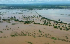
NASA have issued satellite images of the recent flooding in Bihar, India.
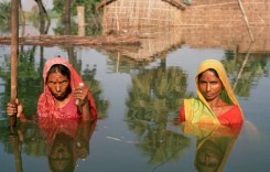
Bihar has been affected by floods since the start of this year’s monsoon, affecting millions and displacing over 600,000.
After a short respite where many were able to return to their homes, further heavy rainfall from around 18 August increased river levels dramatically and once again, thousands of people have been evacuated and are staying in relief camps around the state.
The images show the Ganges river near Patna, the capital of the state. The first image, from August last year, shows the Ganges at more normal levels. The second image shows the hugely swollen river, extending well beyond its normal limits.


NASA says:
The Moderate Resolution Imaging Spectroradiometer (MODIS) on NASA’s Terra satellite captured these false-color images of a stretch of the Ganges River near Patna on August 10, 2015 (top), and August 21, 2016 (bottom). These images use a combination of infrared and visible light to increase contrast between water and land. Water is blue. Vegetation is green. Notice that the water is a slightly lighter shade of blue in the lower image due to all the suspended sediment in the water.
Ganges at Record Levels
According to figures from India’s Central Water Commission of earlier today, the Ganges in Patna district is just 8 cm below the highest recorded.
The Ganges at the Patna Gandhighat measuring station in Patna district, Bihar, stood at 50.19 metres, well above danger level of 48.6 metres.
The highest level recorded at this point is 50.27 metres, from 01 August 1994. Forecasters expect the Ganges to rise further over the next 24 hours to 50.21 metres. From 25 August, levels are expected to start falling.
At the Bhagalpur measuring station in Bhagalpur district, down river and about 200 km east of Patna, the Ganges stands at 34.63 metres, well above the 33.68 danger mark and beating the previous high of 34.5 of September 2013.
In Uttar Pradesh, the Ganges has also exceeded previous records at the Ballia station in Ballia district. Levels there are currently at 60.37 metres, again well above the danger mark of 57.615 and beating the previous high of 60.25 set in September 2003.
Dozens Killed, Thousands Evacuated
The floods in Bihar and Uttar Pradesh have forced thousadns from their homes and into relief camps.
Local disaster management officials say that over 100 people have died in floods in Bihar since the start of the monsoon.
Over 40 people have died in the most recent spate of floods to hit Uttar Pradesh.